Maps of Shakespeare's London, and What They Get Wrong
Wenceslaus Hollar's 1647 view of London puts the label "The Globe" on the wrong building. The round theatre he called "Beere bayting" is the Globe, according to the Royal Collection Trust, which holds a copy. Each of the other maps and views in this post has a catch of its own.
Here are seven of them in date order, with what each one shows of the theatres and what you need to watch for. For where each playhouse was and what's on the spot today, see our guide Where Were Shakespeare's Theatres?.
| Map or view | Date | Playhouses shown | The catch |
|---|---|---|---|
| Copperplate map | c.1553-59 | None (no Bankside plate survives) | Only three plates survive, and none covers Bankside |
| Woodcut ("Agas") map | Made 1561-70 | None; two baiting rings on Bankside | Every surviving copy is an altered printing of about 1633, and Agas didn't make it |
| Braun and Hogenberg | 1572 | None; two baiting rings | Drawn from an earlier map, according to Roger Clegg and Joseph Quincy Adams |
| Norden's map | 1593 | "The play howse" (the Rose) | Adams says the two buildings are "crudely drawn", and that the bear house was really polygonal (many-sided) |
| Norden's Civitas Londini | 1600 | The Rose, the Swan, the first Globe | The Rose is labelled "The Stare" |
| Visscher's view | 1616 | "The Swan", "The Bear Gardne", "The Globe" | Probably drawn in Amsterdam from older pictures |
| Hollar's Long View | 1647 | The second Globe and the Hope | Their labels are swapped |
One warning applies to the early maps. Roger Clegg, writing about the Rose, points out that mapmakers "often copied each other". He says the early maps were commissioned by the City livery companies (the City's trade guilds), who cared about drawing the City, so detail south of the river is "often more representative or artistic".
I. A. Shapiro, writing in 1948 about engravings from the reigns of James I and Charles I in general, gave a similar warning. He argued that writing about the Bankside playhouses had been spoiled by "uncritical acceptance of certain Jacobean and Caroline engravings", and that the date and authenticity of each view had to be settled first.
The Copperplate map (c.1553-59)
This map was printed from about 15 copper plates. Only three plates survive, and not a single printed sheet. Two plates are at the London Museum and the third is in a gallery in Dessau, Germany.
The London Museum says it was probably engraved in the Netherlands between 1553 and 1559, and that nobody knows who paid for it. So we can't tell whether Clegg's point about the livery companies applies here. Once worn out, plates were sold to artists who painted on the back, and one London Museum plate has the Assumption and Coronation of the Virgin painted on its reverse.
None of the surviving plates shows Bankside, so we can't say what it drew there. It matters anyway, because the Map of Early Modern London says the next map, the woodcut, is based on it.
The woodcut map, or "Agas" (made 1561-70)
You'll often see this one called the Agas map, after the surveyor Ralph Agas. The Map of Early Modern London calls that a "spurious attribution", and The London Archives says nobody knows who made it. The map, titled Civitas Londinum, was printed from eight wooden blocks and is based on the Copperplate.
Here's the catch with its date. The London Archives dates it to between 1561 and 1570, but all three surviving copies come from a printing of about 1633. That printing was altered: the Stuart royal arms replaced the Tudor ones, and the Royal Exchange was added.
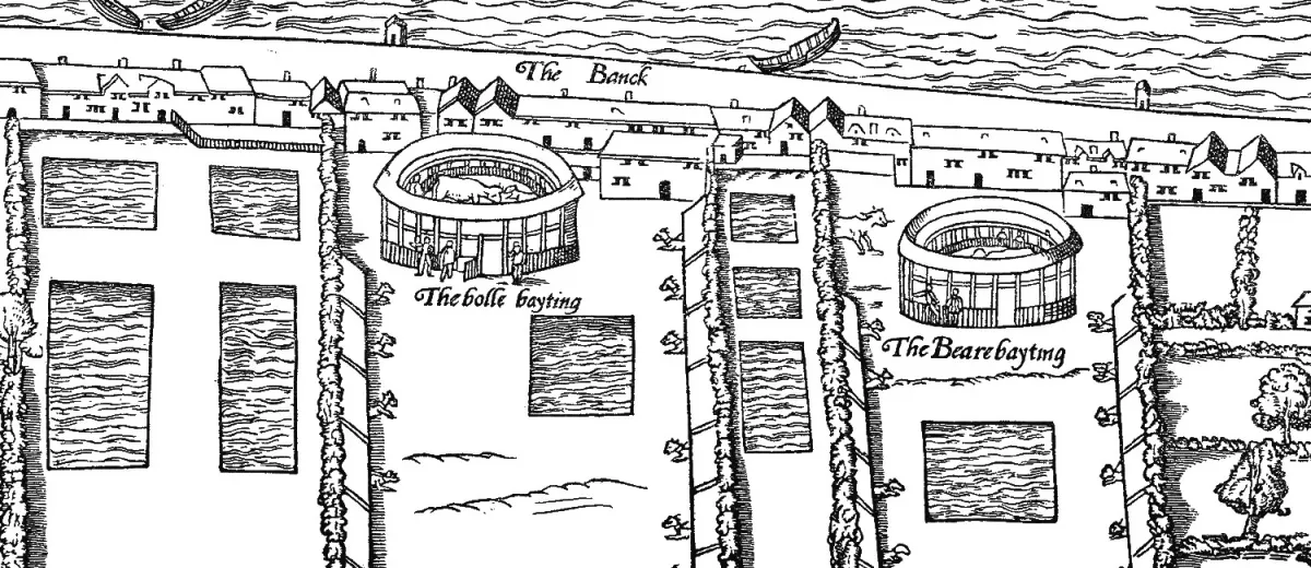
On Bankside it shows two round arenas, labelled "The bolle bayting" (bull-baiting) and "The Bearebayting". You can see dogs tied up along the fences and rectangular fishponds, in the area the Records of Early English Drama project (REED) calls the Pike Gardens. Sally-Beth MacLean of the REED project writes: "We can assume that significant artistic license has been taken but it is certainly possible that two enclosures of some sort existed".
There are no playhouses on it. ShakespeareGo's reading is that this is down to the date: the Rose, built in 1587, is the earliest Bankside playhouse in this post.
Braun and Hogenberg (1572)
This plan was published in Cologne in 1572, in the first volume of Civitates Orbis Terrarum by Georg Braun and Frans Hogenberg.
Bankside has its "stews", which Clegg describes as "inns, gambling dens, and brothels", and the bull- and bear-baiting rings. Joseph Quincy Adams, writing in 1917, describes the rings as two "well-appointed amphitheatres, with stables and kennels attached". Small huts on the riverbank have been read as latrines by Bowsher and Miller in their book The Rose and the Globe, as Clegg reports.
Clegg, drawing on Bowsher and Miller, says it "was drawn from an earlier map in 1560". Adams went further: he thought the woodcut and Braun and Hogenberg were both based on "the same original map, 1554-58". If he's right, ShakespeareGo's reading is that their matching baiting rings count as a single piece of evidence.
John Norden's map (1593)
John Norden's little map of London came out in 1593 in the Middlesex part of his Speculum Britanniae, engraved by Pieter van den Keere. It is framed by the shields of 12 livery companies and has a key, in letters and numbers, to 45 streets and places.
Of the maps here, it is the first to label a Bankside playhouse. South of the riverside houses are two circles, labelled "The Beare howse" and "The play howse". REED and Adams both identify the play howse as the Rose; the Swan came in about 1595 and the Globe in 1599.
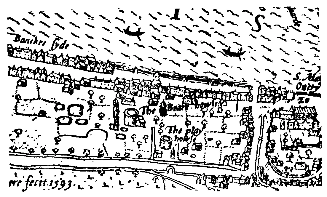
Adams thought the two buildings were "correctly placed" in relation to each other but "crudely drawn". Norden draws both as circles, while the Bear Garden, Adams says, "was polygonal".
Norden's Civitas Londini (1600)
Seven years later Norden made a big panorama of London. The Early Modern London Theatres database dates it to between March and October 1600, and a copy is held by the National Library of Sweden in Stockholm.
It has an inset map of London and part of Southwark, and on the inset the Rose is labelled "The Stare", the Swan is "The swone" and the bear garden is "Bearegarden". The Swan turns up in the panorama too, where REED says it looks "suggestively polygonal". Separately, REED reproduces a detail from Civitas Londini showing the first Globe, built the year before, with a thatched roof among trees.
Roger Clegg thinks Bankside was "unlikely to have been as heavily wooded" as Norden shows it.
Claes Visscher's view (1616)
You may well have seen this one: a long panorama with the river across the middle and the Bankside playhouses in the foreground. Claes Jansz Visscher published it in Amsterdam in 1616. It was engraved on four sheets.
The Folger Shakespeare Library says Visscher was "probably never in London himself" and was "likely working off of previously published images, probably from around 1600". Jeremy Smith of the London Metropolitan Archives (now The London Archives) calls it "a work purporting to depict London, but originating entirely from a desk in Amsterdam".

Three buildings are labelled on Bankside: "The Swan", "The Bear Gardne" and "The Globe". Each is a tall tower with a flag. The Folger points out that Visscher's Globe is a "tower-like octagon", while the real Globe is now thought to have been a many-sided polygon.
Adams treated it as the first Globe, drawn as the city was "several years earlier" than 1616. He also thought Visscher had "rather slavishly copied" the woodcut's Bankside and added the playhouses.
Others copied and re-engraved it many times, including a version published in Venice in 1629. Jeremy Smith notes that Victorian facsimiles (printed copies of the original) came out "without a word of commentary", apparently made for office and tavern walls.
Wenceslaus Hollar's Long View (1647)
Hollar drew his view from the tower of St Saviour's church, which is now Southwark Cathedral. It was published by Cornelius Danckers in 1647, on seven sheets from six plates, and runs to nearly nine feet long.
On the Bankside sheet are two round buildings. The one further inland is labelled "Beere bayting", and the one nearer the river, flying a flag, is labelled "The Globe". The Royal Collection Trust says the "Beere bayting" building is in fact the Globe and the riverside one is the Hope, and the Map of Early Modern London agrees.
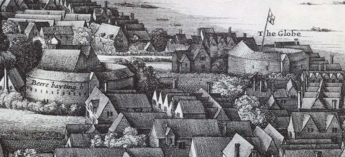
The swap fooled Adams. In 1917 he took the labels at face value and treated the building Hollar labels "Beere bayting" (Adams calls it the "Bear Baiting House") as the Hope. The Map of Early Modern London notes that Hollar copied some of his labels from Visscher's 1616 view, though it doesn't say the swap came from there.
There's another catch. The Globe Hollar drew is the second one, built in 1614; Shakespeare's own Globe of 1599 had burned in 1613. ShakespeareGo's view is that by the time the print appeared in 1647 it had likely gone: one old note says it was pulled down in April 1644, and houses stood on the site by 1655.
In the early 1980s John Orrell climbed the cathedral tower with a copy of Hollar's view and a modern map. He found they "lined up so accurately" that he judged it the best evidence for the Globe's size. Today's Shakespeare's Globe was built to Orrell's reading.
Adams was less impressed. Writing in 1917, he said the Globe is represented "unsatisfactorily" in Hollar's view, and that Hollar "was in banishment from England between the years 1643 and 1652", so "he may have had to rely upon his memory". Bear in mind that Adams meant the building labelled "The Globe", which the Royal Collection Trust and the Map of Early Modern London identify as the Hope.
Seeing the maps yourself
You can look at most of these online for free. The Map of Early Modern London has an interactive version of the woodcut map. The Folger has a page on its copy of Visscher's view, and the Royal Collection Trust has the Bankside sheet of Hollar's Long View.
If you want to compare them, look at the same patch of Bankside on each: the fishponds, the two baiting rings, then the playhouses arriving. And if you're in London, you can visit Southwark Cathedral, whose tower Hollar drew from. Our Shakespeare's Globe venue page has what's on at the reconstruction now.
Sources and further reading
- Map of Early Modern London: Mapography (the maps and their makers)
- Map of Early Modern London: the woodcut ("Agas") map
- London Museum: Copperplate map plate, The Assumption of the Virgin
- London Picture Archive (The London Archives): Civitas Londinum woodcut map
- British History Online: the "Agas" map of London
- REED: Bankside bear gardens and the Hope, by Sally-Beth MacLean
- REED: the Rose playhouse
- REED: the Swan's property
- REED: Norden's Civitas Londini, Bankside detail
- REED: the first Globe in Norden's Civitas Londini
- REED: the Globe
- Roger Clegg, "The topography", Reconstructing the Rose
- Map of Early Modern London: George Braun
- Map of Early Modern London: John Norden
- Early Modern London Theatres: Norden's Civitas Londini
- Folger Shakespeare Library: Visscher's view of London
- London Topographical Society: Visscher's panorama
- Royal Collection Trust: London, the Long View
- Folgerpedia: Old London Bridge in Hollar's Long View of London
- University of Alberta: "Within the wooden O", on John Orrell
- Map of Early Modern London: the Globe
- Joseph Quincy Adams, Shakespearean Playhouses (1917), Project Gutenberg
- I. A. Shapiro, "The Bankside Theatres: Early Engravings", Shakespeare Survey 1 (1948), Cambridge Core
Read the Plays
Test Your Knowledge
Think you know your Shakespeare? Put it to the test with one of our free quizzes.
See all quizzes →